
Landscape Art, Category:Landscape art, Landscape, Category:Painting, Category:Art genres, Paisatge (gènere pictòric), Krajinomalba, Landskabsmaleri, Landschaftsmalerei, Maastikumaal, Pintura del paisaje, Pejzaĝismo, Paysage dans l'art, Peyzaj, 풍경화, Բնանկար, Pejzaž (likovni), Pittura paesaggistica, Пейзаж, Ainava (žanrs), Peizažas, Tájkép, Пејзажно сликарство, Landschapschilderkunst, 風景画, Landskapsmaleri, Pejzaż, Pintura de paisagem, Пейзаж, Krajinsko slikarstvo, Пејзаж у сликарству, Maisemamaalaus, Landskapsmåleri, จิตรกรรมภูมิทัศน์, Peyzaj, Пейзаж, Category:Nicaraguan artists, Category:People from Masaya Department, Category:Classic realism artists, Category:Figurative artists, Category:American painters, Category:American artists, Category:American contemporary artists, Category:Artists from Mississippi, Category:American people of Nicaraguan descent, Category:Nicaraguan artists, Category:Classical artists |
| Envíe esta página de Children playing at the beach with volcano Concepcion at Lake Nicaragua a un amigo | ||||
|
||||
|
||||
Imágenes de Nicaragua |
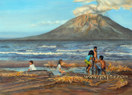
Children playing at the beach with volcano Concepcion at Lake Nicaragua |
|||||||||||||||||||||||||||||||||||||||||||||||||||||||||||||||||||||||||||||||||||||||||||||||||||||||||||||||||||||||||||||||||||||||||||||||||||||||||||||||||||||||||||||
 |
|||||||||||||||||||||||||||||||||||||||||||||||||||||||||||||||||||||||||||||||||||||||||||||||||||||||||||||||||||||||||||||||||||||||||||||||||||||||||||||||||||||||||||||
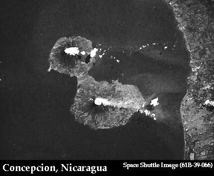
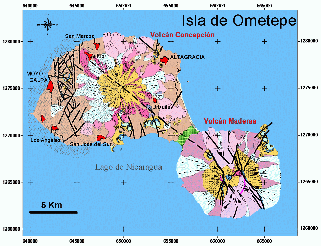
Here we have depicted children playing in sand, in front of Lake Nicaragua with Volcano Concepcion in the background which is one of the Major Volcanoes of Nicaragua. This is an idyllic scene of children playing at the beach during a tropical afternoon of Lake Nicaragua, with the Conception Volcano looming in the background. Children have been playing on this beach since long before the Conquistadors. A volcano is a geological landform usually generated by the eruption through a planet's surface of magma, molten rock welling up from the planet's interior. Other forms of volcano include ice volcanoes (particularly on some moons of Jupiter, Saturn and Neptune) and mud volcanoes. On Earth, volcanoes tend to occur near the boundaries of crustal plates. Important exceptions exist in hotspot volcanoes, which occur at locations far from plate boundaries; hotspot volcanoes are also found elsewhere in the solar system, especially on its rocky planets and moons. The name "volcano" is thought to derive from Vulcano, a volcanic island in the Aeolian Islands of Italy whose name in turn originates from Vulcan, the name of a god of fire in Roman mythology. The study of volcanoes is called volcanology (sometimes spelled vulcanology). The Major volcanoes in Nicaragua are, Cerro Negro, Concepción (volcano), Cosiguina, Las Lajas (volcano), Las Pilas, Maderas, Masaya Volcano, Mombacho Concepción is one of the two volcanoes which make up the island of Ometepe, situated in Lake Nicaragua in Nicaragua, Central America. Concepción is an active volcano, having last erupted in 1998. Concepción is a strato volcano that forms the northwest part of the Isla de Ometepe. Since 1883 Concepción has erupted at least 24 times. Eruptions are characterized by frequent moderate-sized explosions. Fumaroles are active just north of the summit crater at an elevation of 5,577 feet (1,700 m). Concepción - jeden z dwóch wulkanów, polozonych na wyspie Ometepe (drugi to Maderas), wyspie na Jeziorze Nikaragua. Ma on postac stratowulkanu, który wznosi sie na wysokosc ok. 1700 m n.p.m. Wspólrzedne geograficzne: 11°32'N 85°37'W. Concepción jest czynnym wulkanem. Od 1883 wulkan wybuchal przynajmniej 24 razy, a ostatnia erupcja miala miejsce w 2005 (wczesniej w 1998). Ze wzgledu na duza czestotliwosc erupcji, ich rozmiary sa raczeh niewielkie. Na pólnoc od krateru znajduje sie aktywne pole fumarol. Der Concepción ist ein Stratovulkan in Nicaragua. Zusammen mit dem Nachbarvulkan Madera bildet er die Insel Isla de Ometepe im Nicaraguasee. Der letzte Ausbruch datiert auf das Jahr 1999. Durch zahlreiche Ausbrüche in der letzten Hälfte des Jahrhunderts ist die Höhe deutlich über die in den meisten Aufzeichnungen angegebene angewachsen.
NicaraguaseeDer Nicaraguasee (spanisch Lago de Nicaragua), auch Cocibolca, ist der größte See in Mittelamerika. Er liegt im Südwesten von Nicaragua an der Staatsgrenze zu Costa Rica, ist im Norden mit dem Managuasee verbunden und mit einer Fläche von 8.157 km² der zehntgrößte Süßwassersee der Erde. In ihm leben größere Populationen des Bullenhais, der eine Länge von über drei Metern erreichen kann. Auch einen Sägerochen fand man schon im Nicaraguasee. Im See gibt es mehr als 400 Inseln, die größten sind Zapatera im Norden und Ometepe in der Mitte des Sees. Ometepe besteht aus zwei Vulkanen, dem Vulkan Concepción mit 1.610 m und dem Vulkan Madera mit 1.340 m Höhe. Ausbrüche beider Vulkane haben dazu geführt, dass die ursprünglich zwei Inseln durch die Lavaströme zu einer einzigen Insel zusammengewachsen sind; hier finden sich auch prähistorische Steinstatuen und Petroglyphen. Die vielleicht bekannteste Inselgruppe sind die Solentiname-Inseln im Süden des Sees, wo Ernesto Cardenal lange Zeit lebte. Der See ist auch eine wichtige Verkehrsader, zahlreiche Fährverbindungen verbinden eine Reihe von Uferstädten und die bewohnten Inseln miteinander. Immer wieder gab es Überlegungen über den Río San Juan und den Nicaraguasee eine Verbindung von Pazifik und Atlantik zu realisieren, den Nicaragua-Kanal. Grand Lac Nicaragua, lac de Nicaragua, lac Cocibolca, lac de Granada, mer Douce, lac Doux , Grand Lac , Grand Lac doux , lac du Nicaragua.Le lac Nicaragua est un lac d'eau douce d'Amérique centrale, entièrement situé au Nicaragua. Le lac couvre une superficie de 8 624 km², faisant de lui le deuxième plus grand lac d'Amérique latine (après le lac Titicaca), et le dixième plus grand lac d'eau douce du monde. Le lac est abrite plusieurs îles dont l'île Ometepe et les îles Solentiname. Le lac est relié à la mer des Caraïbes par le fleuve San Juan qui va se jeter dans la mer des Caraïbes. Il est pourtant si proche de l'océan Pacifique que c'est ce dernier que l'on peut apercevoir du sommet de l'île Ometepe. Cette proximité avec l'océan Pacifique a fait que, pendant un temps durant le XIXe siècle, il fut envisagé de profiter de cette configuration pour le percement d'un canal reliant le Pacifique à la mer des Antilles. Le percement aurait ensuite consisté soit en un canal suivant la vallée du río San Juan jusqu'à la mer des Caraïbes à l'est, soit en l'utilisation du cours du fleuve, réputé navigable tout au long de son cours. Cette solution aurait cependant probablement nécessité des aménagements coûteux pour permettre le passage de navires de gros tonnage. Pour diverses raisons, parmi lesquelles la longueur des percements ou des aménagements envisagés (au moins 130 km pour le Nicaragua contre 77 km seulement au Panamá), les investisseurs préférèrent finalement la solution du percement de l'isthme de Panamá. Le projet d'un second canal interocéanique traversant le Nicaragua refait toutefois périodiquement surface. Le projet le plus crédible dont il était question en 2003 se heurte à des obstacles liés à son coût élevé (20 à 25 milliards de dollars US), alors que le budget annuel du pays avoisine le milliard de dollars) mais aussi à l'impact sur l'environnement[2]. Lago NicaráguaO Lago Nicarágua ou Lago Cocibolca é um lago da Nicarágua com uma área de 8.624 km2. O Lago Nicarágua é o segundo maior lago da América Latina, pouco menor que o Lago Titicaca. Com uma elevação de 32 metros acima do nível do mar, o lago atinge uma profundidade de 26 metros. Nicaragua (järvi)Nicaragua eli Cocicolba on järvi Nicaraguassa. Se on pinta-alaltaan Nicaraguan ja Keski-Amerikan suurin sekä Latinalaisen Amerikan toiseksi ja maailman 20. suurin järvi. Latinalaisessa Amerikassa vain Titicaca on suurempi. Tipitapa-joki yhdistää Nicaraguan Managuajärveen [1]. Järven pinta-ala on 8 157 km² ja suurin syvyys 70 metriä. Muiden muassa Granadan, Rivasin, San Carlosin ja San Migueliton kaupungit sijaitsevat Nicaraguajärven rannalla. Nicaraguajärvessä on yli 400 saarta, joista suurimmat ovat Zapatera ja Ometepe. ニカラグア湖ニカラグア湖(スペイン語: Lago de Nicaragua)又はCocibolca湖は、ニカラグアにある 淡水湖である。面積は8029km2で、ラテンアメリカではチチカカ湖に次いで2番目に広い湖であり、世界で10番目に大きい淡水湖である。 現地の人はこの湖をCocibolca湖又はDulce湖(「甘い海」の意味)と呼ぶ。実際、この湖は水が塩分を含んでいないことを除けば海とほとんど変わりがない。西にある太平洋からの東風によって海のように波が立つ。また、オメテペ島やSolentiname列島のような島々がある他、淡水遡上性のあるオオメジロザメ(サンフアン川でよく見られる)も生息することがよく知られている。さらには、定期的に強力な暴風雨を発生させることでも知られている。 ニカラグア湖は、サンフアン川でカリブ海とつながっており、歴史的に湖岸のグラナダは、大西洋の港とされている。湖の歴史には、カリブ海の海賊の出現も記されている。川はカリブ海につながっているが、湖は太平洋に近い位置にあり、湖の中のオメテペ島の山から見ることもできる。パナマ運河の完成前、駅馬車線が狭い地峡を経て小高い丘を抜けて太平洋につながっていた。最初の大洋間をつなぐ運河の計画は、ニカラグア運河としてこのルートを利用することを考えたが、代わりにパナマ運河が作られた。ニカラグア国内では現在でも定期的に自国に運河を作る計画が持ち上がる。 |
|||||||||||||||||||||||||||||||||||||||||||||||||||||||||||||||||||||||||||||||||||||||||||||||||||||||||||||||||||||||||||||||||||||||||||||||||||||||||||||||||||||||||||||
|
|||||||||||||||||||||||||||||||||||||||||||||||||||||||||||||||||||||||||||||||||||||||||||||||||||||||||||||||||||||||||||||||||||||||||||||||||||||||||||||||||||||||||||||
|
|||||||||||||||||||||||||||||||||||||||||||||||||||||||||||||||||||||||||||||||||||||||||||||||||||||||||||||||||||||||||||||||||||||||||||||||||||||||||||||||||||||||||||||
Landscape Art, Category:Landscape art, Landscape, Category:Painting, Category:Art genres, Paisatge (gènere pictòric), Krajinomalba, Landskabsmaleri, Landschaftsmalerei, Maastikumaal, Pintura del paisaje, Pejzaĝismo, Paysage dans l'art, Peyzaj, 풍경화, Բնանկար, Pejzaž (likovni), Pittura paesaggistica, Пейзаж, Ainava (žanrs), Peizažas, Tájkép, Пејзажно сликарство, Landschapschilderkunst, 風景画, Landskapsmaleri, Pejzaż, Pintura de paisagem, Пейзаж, Krajinsko slikarstvo, Пејзаж у сликарству, Maisemamaalaus, Landskapsmåleri, จิตรกรรมภูมิทัศน์, Peyzaj, Пейзаж, Category:Nicaraguan artists, Category:People from Masaya Department, Category:Classic realism artists, Category:Figurative artists, Category:American painters, Category:American artists, Category:American contemporary artists, Category:Artists from Mississippi, Category:American people of Nicaraguan descent, Category:Nicaraguan artists, Category:Classical artists |